
versteckte plätze in sydney
Ku-Ring-Gai Chase Nationalpark - Northern Beaches
|
Stand 2021 – Aktuelle Infos immer direkt auf der Website: Aktuelle Fährzeiten: Fantasea Busfahrten: Transport NSW |
Die Northern Beaches sowie der Ku-Ring-Gai Chase National Park sind einfach mit dem Bus zu erreichen und stehen jenen Beaches und Orten in Sydney selber wie 'Bondi', 'Bronte' oder 'Manly Beach' in keiner Weise nach. Bei den 'Northern Beaches' ist es jedoch ruhig, die Strände sind fast leer, und es scheint, als ob sich kaum ausländische Touristen hierher verirren. Auch Asiatische Touristen (welche Sydney beinahe vollständig in Beschlag nehmen) findet man hier kaum.

Zweifellos ein Juwel der Region rund um Sydney ist der Ku-ring-gai Chase National Park.
Diesen erreicht man – ebenso wie die Northern Beaches – mit folgenden Bussen:
Ab Wynyard: 190X + 199 oder B1 + 199 (transportnsw)
An den wunderschönen Northern Beaches kann man an vielen Stellen aussteigen. Hier trifft man nur selten auf andere Touristen und spürt förmlich den echten Australian-Surf-Spirit.
Fährt man die Busroute fast bis zum Ende, zur Haltestelle beim Pittwater Park (Barrenjoey Rd., gegenüber der Palm Beach Wharf), bietet sich ein Besuch des gegenüberliegenden Ku-ring-gai Chase National Parks geradezu an.
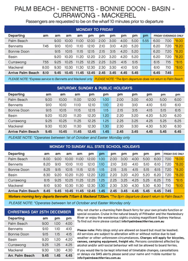
Hier befindet sich der kleine, hübsche Fährterminal, von dem aus ein kleines Personenboot nach Mackarel Beach ablegt. Die Tickets bezahlt man bar direkt an Bord, nach der Abfahrt.
Fantasea: die aktuellen Fährzeiten
Ein Besuch der Northern Beaches und des Ku-ring-gai Chase National Parks lässt sich – vorausgesetzt, man plant die Fährzeiten gut – problemlos an einem Tag kombinieren.
Video:

Map (vergrössern durch Mausklick)

einige tolle Wanderungen
(alle sind auch ab Mackarel Beach möglich bzw. mit der Fähre erreichbar)
Länge: 3.5 km Circuit
Höhendifferenz: 243 m
This walk is a great way to see two major Aboriginal sites and up to three of Ku-ring-gai Chase’s beaches. The circuit walk visits Red Hands Cave and some historic engravings, in addition to enjoying expansive views over Pittwater, with Barrenjoey Headland as a feature. The walk includes Resolute and West Head beaches and the option of a side trip to Mackerel Beach as well. To top it all off, this walk has an added bonus of a WWII gun emplacement to explore.
Länge: 8.6 km Circuit
Höhendifferenz: 422m
The Mackerel Beach, West Head Loop is a walk
which explores a large part of the West Head. The
journey starts and finishes with a ferry across
Pittwater. The walk heads around West Head, taking
in views on the Broken Bay side, with Lion Island
featuring as a prominent sight. The walk follows
sections of road that connect some fantastic bush
tracks together. This is a solid day walk if allowing
time to relax and have a dip at one of the many
beaches along the way.
Länge: 5.4 km Circuit
Höhendifferenz: 384m
This walk is another great walk in Ku-ring-gai Chase
National Park, accessed by ferry. From the Mackerel
Beach wharf, this walk uses the Resolute Loop track
to round the headland, enjoying a few secluded
beaches and excellent, historic Aboriginal sites. This
walk features Mackerel Beach and community, with
an alternative route through the town which is well
worth the walk.
Kommentar schreiben